Doprava zdarma pre objednávky nad 59,99 € s Packetou a SPS Boxmi.
Staňte sa súčasťou komunity milovníkov kníh z celého sveta a získajte hromadu výhod.
Založiť účet zdarma
Doprava zadarmo s Packetou nad 59.99 €
Kuriér DPD 2.99 €
Zberné miesto GLS 2.99 €
SPS 3.99 €
Kuriér GLS 3.49 €
SPS Parcel Shop 2.99 €
Packeta kurýr 3.99 €
Pošta 3.99 €
Zberné miesto DPD 2.99 €
Zberné miesto DPD 0.00 €
Packeta 2.99 €
 Kontakt
 Ako nakupovať
Pomoc
Doručenie
Kuriér DPD 2.99 €
Zberné miesto GLS 2.99 €
SPS 3.99 €
Kuriér GLS 3.49 €
SPS Parcel Shop 2.99 €
Packeta kurýr 3.99 €
Pošta 3.99 €
Zberné miesto DPD 2.99 €
Zberné miesto DPD 0.00 €
Packeta 2.99 €
Doprava zadarmo s Packetou nad 59.99 €
Nákupný poradca
Sme tu pre Vás!
02/210 210 99
Môj účet
▸
Prázdny :-(
0
Doprava zdarma pre objednávky nad 59,99 € s Packetou a SPS Boxmi.
Remote Sensing and GIS Based Lithological Mapping
Jazyk
 Angličtina
Angličtina
Kniha
Brožovaná
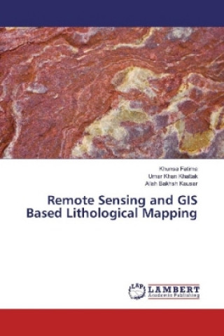
Remote sensing and GIS techniques assist geologists by providing valuable information about geology...
Celý popis
Libristo kód: 16045147
?
 78 b
78 b
78 b
32.06
€
Skladom u dodávateľa
Odosielame za 5-8 dní
30 dní na vrátenie tovaru
Zákazníci tiež kúpili


 /
/
 Kalendár
 29.23
€
29.23
€


 /
/
 Brožovaná
14.76
€
Brožovaná
14.76
€


Remote sensing and GIS techniques assist geologists by providing valuable information about geology and minerals of an area to be surveyed, so that geologists spend quality and focused time in the field. The lithology of Khaira Murat Range, Attock Pakistan is studied using Landsat ETM+ and ASTER Satellite images. The shortwave infrared and thermal infrared bands of Landsat and ASTER successfully mapped industrial minerals like calcite, quartz, muscovite and montmorillonite.
Herečka
&
Polyglotka
EWA KASP
pre
Prehrať video


Libristo má najväčší výber cudzojazyčnej literatúry. Preto si knihy kupujem tu.
Informácie o knihe
Celý názov
Remote Sensing and GIS Based Lithological Mapping
Jazyk
Angličtina
Angličtina
Väzba
Kniha - Brožovaná
Dátum vydania
2017
Počet strán
68
EAN
9783330045781
Libristo kód
16045147
Nakladateľstvo
LAP Lambert Academic Publishing
Váha
119
Rozmery
150 x 220 x 4

Darujte túto knihu ešte dnes
Je to jednoduché
1 Pridajte knihu do košíka a vyberte možnosť doručiť ako darček 2 Obratom Vám zašleme poukaz 3 Knihu zašleme na adresu obdarovanéhoMohlo by vás tiež zaujímať

 /
Brožovaná
44.51
€
/
Brožovaná
44.51
€


 /
/
 Adobe ePub DRM
4.44
€
Adobe ePub DRM
4.44
€
 /
Brožovaná
57.76
€
/
Brožovaná
57.76
€