 Kontakt
 Ako nakupovať
Doručenie
Nákupný poradca
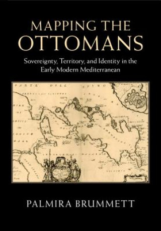
Mapping the Ottomans
Sovereignty, Territory, and Identity in the Early Modern Mediterranean
 Angličtina
 134 b
134 b
30 dní na vrátenie tovaru
Zákazníci tiež kúpili


 /
/
 Brožovaná
 48.39
€
48.39
€


Simple paradigms of Muslim-Christian confrontation and the rise of Europe in the seventeenth century do not suffice to explain the ways in which European mapping envisioned the 'Turks' in image and narrative. Rather, maps, travel accounts, compendia of knowledge, and other texts created a picture of the Ottoman Empire through a complex layering of history, ethnography, and eyewitness testimony, which juxtaposed current events to classical and biblical history; counted space in terms of peoples, routes, and fortresses; and used the land and seascapes of the map to assert ownership, declare victory, and embody imperial power's reach. Enriched throughout by examples of Ottoman self-mapping, this book examines how Ottomans and their empire were mapped in the narrative and visual imagination of early modern Europe's Christian kingdoms. The maps serve as centerpieces for discussions of early modern space, time, borders, stages of travel, information flows, invocations of authority, and cross-cultural relations.


Informácie o knihe
Angličtina
Kategórie

Darujte túto knihu ešte dnes
Je to jednoduché
1 Pridajte knihu do košíka a vyberte možnosť doručiť ako darček 2 Obratom Vám zašleme poukaz 3 Knihu zašleme na adresu obdarovanéhoMohlo by vás tiež zaujímať


 /
Brožovaná
14.07
€
/
Brožovaná
14.07
€


Ahoj! Som Libroamiko, tvoj knižný radca.
Ako ti môžem pomôcť?